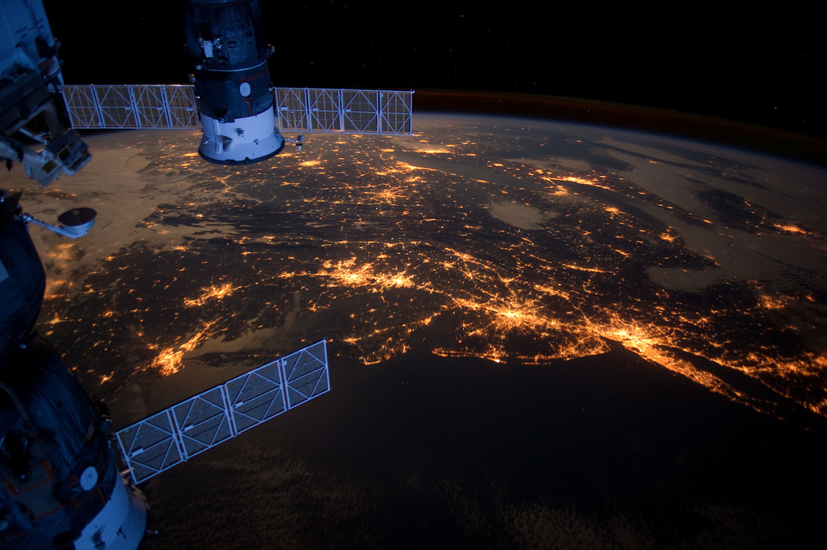
The East Coast of the United States at night, as seen from the International Space Station. Photo-credit: NASA CLICK ON IMAGE TO ZOOM
To Teachers: you can pass this post on to your students as a home activity, so they can watch live video of the Earth from the International Space Station.
Feedback on this Teachable Moment is welcome. Feel free to leave a comment at the bottom of the post.
Concepts addressed:
Physics and Space: a spacecraft in Low Earth Orbit as an observing platform – apparent size of Earth, apparent motion of Earth due to spacecraft speed, frequency of day/night variation
Geography: characteristics of Earth observable from orbit – clouds, storms, land masses, bodies of water, views during the day and at night
Mathematics: using ratios and proportions
Music: using music to impact a visual experience
Imagine you’re an astronaut on the International Space Station (ISS), orbiting the Earth at an altitude of about 260 miles (420 km). When you get a chance, you peer out your window, and look down on your world from space. What would you see?
You may not know this but there are video cameras on Station that look down on Earth continuously, and NASA sends the live feed back to Earth, so you can see what the astronauts are seeing right now. It is called HDEV – the High Definition Earth Viewing Experiment.
In the portal below you can watch high definition video of your world being telemetered to Earth LIVE from the International Space Station.
To determine what portion of Earth is in view, use the ‘ISS Current Location Tracker’, which was the subject of a prior post ‘SSEP Teachable Moment – where Above the Earth is the International Space Stationn right Now?”
Note: If the image is black in the video portal below, ISS is on the night side of Earth. To check, use the ISS Current Location Tracker. Note: ISS orbits Earth in 90 minutes, with 45 minutes of daylight followed by 45 minutes of darkness.
We invite you to use this live video feed to get into the spirit of exploration on the frontiers of space – expand the video window (in a classroom, use a LCD projector to display on a large screen), select and play an audio file below, and look down from 260 miles above Earth’s surface. (Suggestions for other audio tracks are welcome:)
David Bowie’s Space Oddity, sung by Canadian Astronaut Chris Hadfield on ISS (watch his video)
Superman
Star Trek TNG
About HDEV, from NASA: The High Definition Earth Viewing (HDEV) experiment aboard the ISS was activated April 30, 2014. It is mounted on the External Payload Facility of the European Space Agency’s Columbus module. HDEV includes four fixed cameras positioned to capture imagery of the Earth’s surface and its limb as seen from the ISS – one camera pointing in the direction the station is moving, two cameras aft (wake), and one camera pointing straight down at Earth (nadir). While the experiment is operational, views will typically sequence though the different cameras. Between camera switches, a gray and then black color slate will briefly appear. To learn more about the HDEV experiment, visit this NASA webpage.
Some Things to Ponder
Click on the image at the top of the post to expand the view –
What do you think might be giving off all the light? Think of different sources of light.
Compare the image to a detailed map of the east coast of the United States. How much of the East Coast is visible in the image? What cities can you identify? What bodies of water can you identify? What is the I-95 corridor, and can you see it?
What are the spacecraft in the foreground attached to the International Space Station? What are they used for? Why are there two of them?
In the HDEV video portal above –
How much of the Earth can you see at once? What is your impression, is it a lot or a little?
Hint: using a globe of the Earth, determine how high ISS orbits the Earth relative to the globe. The Earth is 8,000 miles in diameter (12,000 km), and ISS orbits an an altitude of about 260 miles (420 km). Set up a proportion to determine how high above the globe you would need to put a tiny model of ISS. Now put one eye at that height above the globe, close the other eye, and see how much of the Earth you see.
What is the ‘horizon’? Can you locate the horizon in the video?
Why is the Earth seen to be rotating?
Can you see land masses? Clouds? Bodies of water?
Use the ISS Current Location Tracker to see what the International Space Station is flying over right now, and see if you can recognize anything in the live video.
The Student Spaceflight Experiments Program (SSEP) is a program of the National Center for Earth and Space Science Education (NCESSE) in the U.S., and the Arthur C. Clarke Institute for Space Education internationally. It is enabled through a strategic partnership with DreamUp PBC and Nanoracks LLC, working with NASA under a Space Act Agreement as part of the utilization of the International Space Station as a National Laboratory. SSEP is the first pre-college STEM education program that is both a U.S. national initiative and implemented as an on-orbit commercial space venture.
The Smithsonian National Air and Space Museum, the International Space Station U.S. National Laboratory, and Subaru of America, Inc., are U.S. National Partners on the Student Spaceflight Experiments Program. Magellan Aerospace is a Canadian National Partner on the Student Spaceflight Experiments Program.